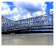
Kolkata is located in the eastern part of India at 22°82′ N 88°20′ E. It has spread linearly along the banks of the river Hooghly.
The Kolkata Municipal Corporation has an area of 185 square kilometres. The city proper today can be roughly divided into two sections along Mother Teresa Sarani (Park Street). North of Park Street is the more congested part of the city. South of Park Street is the slightly better planned section of the city.
The old Central Business District (CBD) is where the seat of the West Bengal Government is located, along with many other government offices. Several banks have their corporate (Allahabad Bank, United Bank of India, UCO Bank) or regional headquarters (Reserve Bank of India, State Bank of India, Bank of India, Central Bank of India amongst many others) around the B. B. D. Bagh area. Many of Kolkata's older business groups have their main offices here. The area is a mix of multi-storeyed office blocks and colonial buildings.
No comments:
Post a Comment